


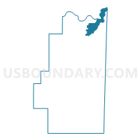
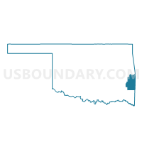
Voting District 105, Le Flore County, Oklahoma
About
Outline

Summary
| Unique Area Identifier | 654264 |
| Name | Voting District 105 |
| County | Le Flore County |
| State | Oklahoma |
| Area (square miles) | 38.27 |
| Land Area (square miles) | 37.71 |
| Water Area (square miles) | 0.56 |
| % of Land Area | 98.53 |
| % of Water Area | 1.47 |
| Latitude of the Internal Point | 35.28186590 |
| Longtitude of the Internal Point | -94.51836660 |
Maps

Graphs
Select a template below for downloading or customizing gragh for Voting District 105, Le Flore County, Oklahoma


Neighbors
Neighoring Voting District (by Name) Neighboring Voting District on the Map
- Voting District 1-K, Sebastian County, AR
- Voting District 102, Le Flore County, OK
- Voting District 102, Sequoyah County, OK
- Voting District 103, Le Flore County, OK
- Voting District 104, Le Flore County, OK
- Voting District 106, Le Flore County, OK
- Voting District 107, Le Flore County, OK
- Voting District 108, Le Flore County, OK
- Voting District 108, Sequoyah County, OK
- Voting District 109, Le Flore County, OK
- Voting District 3-A, Sebastian County, AR
Top 10 Neighboring County Subdivision (by Population) Neighboring County Subdivision on the Map
- Upper township, Sebastian County, AR (76,938)
- Muldrow CCD, Sequoyah County, OK (10,626)
- Roland CCD, Sequoyah County, OK (9,632)
- Spiro CCD, Le Flore County, OK (7,577)
- Pocola CCD, Le Flore County, OK (4,398)
- Cameron CCD, Le Flore County, OK (3,806)
- Arkoma CCD, Le Flore County, OK (2,082)
Top 10 Neighboring Place (by Population) Neighboring Place on the Map
- Fort Smith city, AR (86,209)
- Pocola town, OK (4,056)
- Spiro town, OK (2,164)
- Arkoma town, OK (1,989)
- Fort Coffee town, OK (424)
Top 10 Neighboring Elementary School District (by Population) Neighboring Elementary School District on the Map
Top 10 Neighboring Unified School District (by Population) Neighboring Unified School District on the Map
- Fort Smith Public Schools, AR (89,450)
- Muldrow Public Schools, OK (8,038)
- Spiro Public Schools, OK (6,875)
- Roland Public Schools, OK (4,957)
- Pocola Public Schools, OK (3,946)
- Panama Public Schools, OK (3,348)
- Arkoma Public Schools, OK (2,079)
Top 10 Neighboring State Legislative District Lower Chamber (by Population) Neighboring State Legislative District Lower Chamber on the Map
- State House District 2, OK (37,808)
- State House District 3, OK (35,355)
- State House District 64, AR (27,265)
Top 10 Neighboring State Legislative District Upper Chamber (by Population) Neighboring State Legislative District Upper Chamber on the Map
Top 10 Neighboring 111th Congressional District (by Population) Neighboring 111th Congressional District on the Map
Top 10 Neighboring Census Tract (by Population) Neighboring Census Tract on the Map
- Census Tract 304.02, Sequoyah County, OK (6,617)
- Census Tract 401.02, Le Flore County, OK (4,398)
- Census Tract 403.03, Le Flore County, OK (3,843)
- Census Tract 403.02, Le Flore County, OK (3,806)
- Census Tract 3, Sebastian County, AR (2,640)
- Census Tract 301.03, Sequoyah County, OK (2,640)
- Census Tract 401.98, Le Flore County, OK (2,082)
Top 10 Neighboring 5-Digit ZIP Code Tabulation Area (by Population) Neighboring 5-Digit ZIP Code Tabulation Area on the Map
- 72901, AR (21,591)
- 74948, OK (12,788)
- 74959, OK (6,736)
- 74902, OK (4,095)
- 74932, OK (2,286)
- 74901, OK (1,992)
- 74946, OK (137)